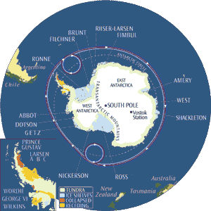
The Antarctic Peninsula is the northernmost part of the mainland of Antarctica, and almost the only part of that continent that extends outside the Antarctic Circle. It lies in the Western Hemisphere, facing South America. It extends from a line between Cape Adams (Weddell Sea) and a point on the mainland south of Eklund Islands, to Prime Head (63º13'S).
The first sighting of Antarctic Peninsula is contested but it apparently occurred in the 1820s. Agreement on this name by the US-ACAN and UK-APC in 1964 resolved a long-standing difference over the use of the American name "Palmer Peninsula" or the British name "Graham Land" for this feature. Graham Land is now that part of the Antarctic Peninsula northward of a line between Cape Jeremy and Cape Agassiz, whilst Palmer Land is the part southward of that line. In Chile, it is officially referred as O'Higgins Land, after the Chilean patriot and Antarctic visionary. The other Spanish countries call it "Península Antártica", among them is Argentina (though also calls it "Tierra de San Martín"), which has more bases and personnel there than any other nation.
The peninsula is highly mountainous, its highest peaks rising to approximately 2,800 metres (9,186 feet). These mountains are considered to be a continuation of the Andes of South America, with a submarine spine connecting the two. That is an argument used by Chile and Argentina for their territorial claims. The peninsula has a sharp elevation gradient, with glaciers flowing into the Larsen Ice Shelf, which experienced significant breakup in 2002.
Since the peninsula has the mildest climate in Antarctica, the highest concentration of research stations on the continent can be found there, or on the many nearby islands.
Hope Bay, at , is near to the northernmost extremity of the peninsula, which is Prime Head, at 63º13'S.

No comments:
Post a Comment