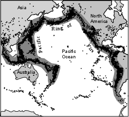
The Pacific Ring of Fire is an area of frequent earthquakes and volcanic eruptions encircling the basin of the Pacific Ocean. In a 40,000 km horseshoe shape, it is associated with a nearly continuous series of oceanic trenches, volcanic arcs, and volcanic belts and/or plate movements. It is sometimes called the circum-Pacific belt or the circum-Pacific seismic belt.
Ninety percent of the world's earthquakes and 81% of the world's largest earthquakes occur along the Ring of Fire. The next most seismic region (5–6% of earthquakes and 17% of the world's largest earthquakes) is the Alpide belt which extends from Java to Sumatra through the Himalayas, the Mediterranean, and out into the Atlantic. The Mid-Atlantic Ridge is the third most prominent earthquake belt.
Cascadia subduction zone
Although little-known to the general public, British Columbia and the Yukon Territory is home to a vast region of volcanoes and volcanic activity in the Pacific Ring of Fire. The volcanoes are grouped into five volcanic belts with different tectonic settings.
Canada
The Stikine Volcanic Belt is the most active volcanic region in Canada. It formed due to extensional cracking, faulting and rifting of the North American Plate, as the Pacific Plate grinds and slides past the Queen Charlotte Fault, unlike subduction that produces the volcanoes in Japan, Philippines and Indonesia. The region has Canada's largest volcanoes, Several eruptions are known to have occurred within the last 400 years. Mount Edziza is a huge volcanic complex that erupted several times in the past several thousand of years, which has formed several cinder cones and lava flows. Hoodoo Mountain is a tuya in northwestern British Columbia, which has had several periods of subglacial eruptions. The oldest eruptions occurred about 100,000 years ago and the most recent being about 7000 years ago. Hoodoo Mountain is also considered active and could erupt in the future. The nearby Tseax River Cones and Lava Fork Valley produced some of Canada's youngest lava flows, that are about 150 years old.
Canada's worst known geophyical disaster came from the Tseax River Cones in 1775 at the southernmost end of the volcanic belt. The eruption produced a 22.5 km long lava flow, destroying the Nisga'a villages and the death of at least 2000 Nisga'a people by volcanic gases and poisonous smoke. The Nass River valley was inundated by the lava flows and contain abundant tree molds and lava tubes. The event happened at the same time with the arrival of the first European explorers to penetrate the uncharted coastal waters of northern British Columbia. Today, the basaltic lava deposits are a draw to tourists and are part of the Nisga'a Memorial Lava Beds Provincial Park.
Stikine Volcanic Belt
The Garibaldi Volcanic Belt in southwestern British Columbia, is the northern extension of the Cascade Volcanic Arc in the United States (which includes Mount Baker and Mount St. Helens) and contains the most explosive young volcanoes in Canada.
Garibaldi Volcanic Belt
The Chilcotin Plateau Basalts are a north-south range of volcanoes in southern British Columbia running parallel to the Garibaldi Volcanic Belt. The majority of the eruptions in this belt happened either 6-10 million years ago (Miocene) or 2-3 million years ago (Pliocene), although there have been some slightly more recent eruptions (in the Pleistocene). Volcanoes in this belt include Mount Noel, the Clisbako Caldera Complex, Lightning Peak, Black Dome Mountain and many lava flows.
Anahim Volcanic Belt
The volcanoes in Indonesia are among the most active of the Pacific Ring of Fire. They are formed due to subduction zones between the Eurasian Plate and the Indo-Australian Plate. Some of the volcanoes are notable for their eruptions, for instance, Krakatau for its global effects in 1883, Lake Toba for its supervolcanic eruption estimated to have occurred 74,000 BP which was responsible for six years of volcanic winter, and Mount Tambora for the most violent eruption in recorded history in 1815.
The most active volcanoes are Kelut and Merapi on Java island which have been responsible for thousands of deaths in the region. Since AD 1000, Kelut has erupted more than 30 times, of which the largest eruption was at scale 5 on the Volcanic Explosivity Index, while Merapi has erupted more than 80 times. The International Association of Volcanology and Chemistry of the Earth's Interior has named Merapi as a Decade Volcano since 1995 because of its high volcanic activity.
Indonesia
The 1991 eruption of Mount Pinatubo is the world's second largest terrestrial eruption of the 20th century. Successful predictions of the onset of the climactic eruption led to the evacuation of tens of thousands of people from the surrounding areas, saving many lives, but as the surrounding areas were severely damaged by pyroclastic flows, ash deposits, and later, lahars caused by rainwater remobilising earlier volcanic deposits, thousands of houses were destroyed.

 Philippines
The Kamchatka Peninsula in the Russian Far East, is one of the most various and active volcanic areas in the world, starting in the north at the Shiveluch volcanic complex, which lies at the junction of the Aleutian and Kamchatka volcanic arcs. Just to the south is the famous Klyuchi volcanic group, comprising the twin volcanic cones of Kliuchevskoi and Kamen, the huge volcanic complexes of Tolbachik and Ushkovsky, and a number of other large stratovolcanoes. The only active volcano in the central belt is found west of here, the huge remote Ichinsky. Farther south, the eastern belt continues to the southern slope of Kamchatka, topped by loads of stratovolcanoes.
Kamchatka Peninsula
The southernmost end of the Pacific Ring of Fire is the continent Antarctica,
Antarctica
The volcanoes of the Victoria Land area are the most well-known in Antarctica,
Marie Byrd Land
Andesite line
Geology of the Pacific Northwest

No comments:
Post a Comment